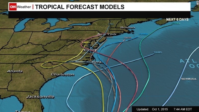
It depends on which model you want to use (there are many) and when you
consult the model. This shows the latest spaghetti tracks:
<http://i2.cdn.turner.com/cnnnext/dam/assets/151001082101-hurricane-joaquin-forecast-models-8-a-m-thursday-exlarge-169.jpg>
and is already quite a bit different than it was 4 hours ago.
Then the yellow track entering North Carolina was actually entering down
near Charleston. The tropical storm of a couple of days ago, not
expected to be other than a tropical storm then, was a category 4 over
the Bahamas this morning with 140 mph winds.
This particular storm has seemed to cause the models a great deal of
difficulty. About the only thing that's relatively certain is that much
of the east coast of the US is going to be very wet.
Stay tuned. It will probably change again. The models have not
suddenly grown smarter in the last few hours.
Chuck Norcutt


On 9/30/2015 4:52 PM, Chris Trask wrote:
     Juaquin has now strengthened to hurricane status, and the forecast is
getting a bit
grim.  The NHC forecast predicts that it will be due east of Norfolk, VA on
Monday, then
heading towards Philadelphia.  An extension of this, seen on CBS this morning,
forecasts
that it will make landfall somewhere between Philadelphia and New York City as
a category
1 storm.
      I've been looking at a few forecasting systems about this, and I can now
see how it is that UKMET Storm Tracker is dramatically different from NHC.  Two
features shown on GFS come into play here, the first being a moderate
low-pressure system that is developing over the southeast.  The second is a
high-pressure system developing north of Bermuda.  The high-pressure system
will give Juaquin a kick to the west, shoving it into the northeast corner of
the low-pressure system, just enough to draw it in and cause it to continue
westward and be absorbed.

      This scenario is similar to that of TS Sandy, and if it proves to be
valid, then the UKMET and GFS forecasts will be correct.  Based on this,
landfall should take place along the North Carolina coast early Sunday and the
storm will proceed rapidly westward.


Chris

When the going gets weird, the weird turn pro
      - Hunter S. Thompson
--
_________________________________________________________________
Options: http://lists.thomasclausen.net/mailman/listinfo/olympus
Archives: http://lists.thomasclausen.net/mailman/private/olympus/
Themed Olympus Photo Exhibition: http://www.tope.nl/
|